Navarino : Inside The Southernmost Trek
Introducing "Los Dientes de Navarino" in Patagonia
Close your eyes and try to imagine the most profound silence on the planet. Here, forget about the crowds. Say goodbye to WiFi. It’s only you and the rugged landscapes of the “end of the world,” further south than Ushuaia (known as “the world’s southernmost city”) and a few kilometers away from Cape Horn, the southernmost place on Earth before Antarctica.
This place is called Navarino Island, and it is located in Chile’s Patagonia, close to Tierra del Fuego (“Land of Fire”). A small island (only 2473km2 / 1058 mi2), the area looks giant considering there are no roads inside the territory (only about 60 kilometers of coastal roads), and most of it has to be explored by foot. Navarino island was pretty unknown not long ago until locals built a 37 km / 23 mi trail through its mountains. With the help of the Chilean government, this locality of only 3000 inhabitants started welcoming thousands of hikers every year. Quick word-of-mouth made “Los Dientes de Navarino” circuit shine as one of Patagonia’s best hiking circuits. And believe me, this reputation is well-deserved.
 Navarino Island may be the wildest place in Patagonia
1. Land in Puerto Williams, the real southernmost city on Earth
Getting there is no joke, and you have three options. It’s either a one-hour flight from Punta Arenas (Chile) with a small plane (you will love the wind gusts on the way!), a two-day cruise from Punta Arenas (scenic but with a high probability of seasickness) or a one-hour sailing adventure from Ushuaia (Argentina). Whichever way you choose you must reach Puerto Williams, a peaceful city at the shore of the Beagle Channel. Puerto Williams was long considered the world’s southernmost village until it officially became a city in 2019.
For your own sake, do not forget anything before you reach Puerto Williams. There are hardly any of stores in the city, and only a couple of hostels for you to stay. Also, its remoteness makes it as beautiful as it is expensive. With excellent viewpoints of the snowcapped mountains and the surrounding forests, this is an incredibly tranquil spot.
2. First steps between the mountains and the sea
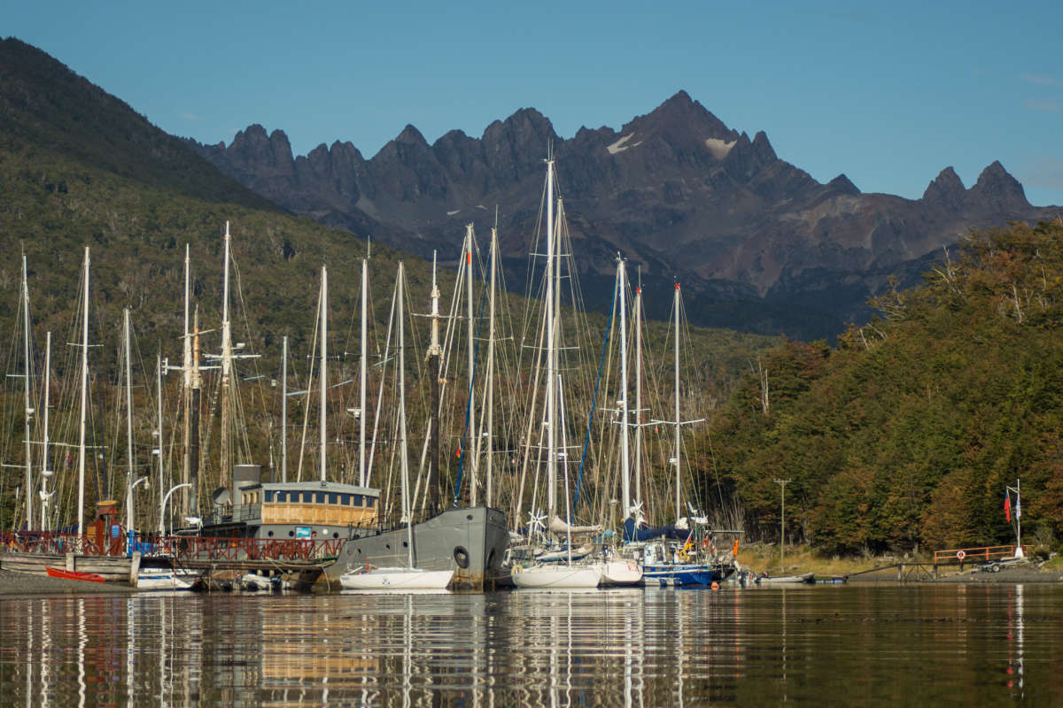 Puerto Williams is a peaceful locality that attracts lots of sailors from around the world
If you decide to hike “Los Dientes de Navarino” circuit without a guide (I can only recommend a guide, see why later), do not forget to notify the local policemen you will be hiking for 4 (or 5) days. This hike is wild and remote, so it’s better to take all precautions.
On day 1, you will hike up for about 600 meters. A steep slope that serves as an excellent warm-up and will offer you the best viewpoint of Beagle Channel, where the sea meets the mountains. It’s also a beautiful lookout of Puerto Williams some reach over a full-day hike. Being on an island in Southern Patagonia makes the walk challenging. The weather is indeed unpredictable (imagine ocean and mountain weather mixed) and the conditions might be severe enough to cause you to slow down a lot. It’s a short yet intense hiking trail.
3. Stay in remote campsites with no infrastructure
If you’ve hiked in places such as Torres del Paine National Park (Chile) or El Chaltén (Argentina), you may have noticed how comfy the campsites and refugees are. Here, this is another story. There are locations for hikers to put their tents and…that’s it. If you need to go to the bathroom, you’ll need to find a tree. Also, most campsites are (very) muddy, so apart from good hiking shoes, you should bring gaiters. Some of the campsites – like “Laguna del Salto” (day 1) – are infamous for the low temperatures/high humidity. So you will need the right technical clothes and a reliable tent. Finally, there are no restaurants on the way. Bringing your own food/gas stove (only cook in places where it’s allowed: no one wants a wildfire) is a must.
 "Laguna del Salto", (Day 1), one of the local campsites
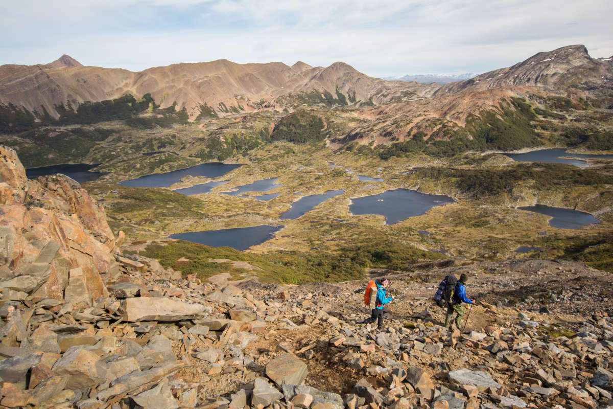
4. Hike along otherworldly mountains
The highlight of this circuit is the diversity of its landscapes, with lush green forests and million-year-old mountain formations. The name of the course (“Los Dientes Teeth”) is a reference to the teeth-like rock formations that can be seen from Puerto Williams. You will hike along these peaks, the highest one reaching 1200 m.s.a.l. That sounds pretty low indeed, but remember the hike starts at sea level.
 The "Virginia Path" offers an amazing view of the Beagle Channel (background)
5. The quietest trail on Earth?
One thing is for sure, the level of quietness on these trails is hard to top. On day 2 and 3, you may meet no more than 20 hikers on the trails. The remoteness and difficulty of the terrain mean that only the most experienced hikers to come, which is a good thing. High season goes from November to March, whereas low season includes the months of September, October, and April. From May to August, it is strongly advised not to hike on those trails, as Winter can be extremely harsh. It is common to lose sight of the path because of heavy snowfall, even in the summer. This is the main reason why I would recommend going with a guide (you don’t want to get lost in those mountains).
Weather tip: With an average high of 12C° (53°F) in summer months and temperatures as low as 0C° (32°F) at night, this constant weather “yo-yo” makes a hike a real adventure.
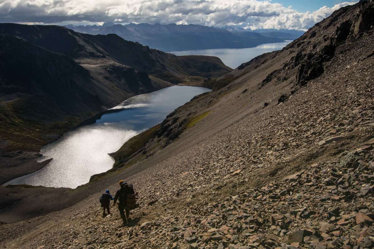
6. Get a sight of “Cape Horn”, the tip of the world
If you’re lucky with the weather, you will get a view of Cape Horn, the Southern Tip of the Americas. An enjoyable experience and the best way to understand what “the Far South” is all about. Now, what does it look like? It is a labyrinth of lakes and valleys, with the immensity of the sea in the background (the Atlantic and Pacific oceans meet here).
It’s hard to find the right words to convince you to do this epic hike, but the key word is “experience.” If you want perfect landscapes, you may want to take a look at Torres del Paine or El Chaltén. But if you’re an avid hiker who wants the ultimate hiking experience in South America without having to struggle with crowds of tourists, “Los Dientes de Navarino” must be on your bucket list. No altitude sickness here (the highest point of the hike is “Paso Virginia” at 850 m.a.s.l) but a real challenge with both the weather and the irregularity of the terrain. And I don’t know if you agree, but I find challenges incredibly exciting.